5 Mighty Rivers of Pakistan You Need to Know About
When you think about what truly keeps a civilization alive — not just surviving, but thriving — water sits at the very top of that list. The rivers of Pakistan are not just flowing bodies of water. They are the lifeblood of an entire nation. From ancient trade routes traced along their banks to the modern-day farmer who wakes before sunrise to irrigate his fields, these rivers have shaped Pakistan’s identity in ways that are almost impossible to overstate. And yet, most people only know a handful of them by name.
Pakistan is home to one of the largest and most complex irrigation systems in the world — and it all starts with rivers. Whether you are a student brushing up for exams, a traveler planning your next adventure, or simply someone curious about the geography that defines South Asia, this guide covers everything. We will walk through the major rivers, their origins, their importance, and the very real challenges they face today. Let’s dive in — literally.
📋 Table of Contents
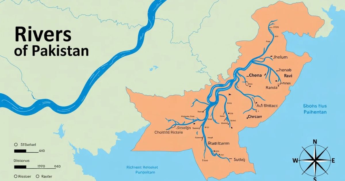
The Indus River System — Pakistan’s Spine
If you had to pick just one river that defines Pakistan, it would be the Indus — no contest. Known locally as the Sindhu, this massive river originates from the Tibetan Plateau near Lake Mansarovar at an altitude of about 5,500 meters. From those icy heights, it flows roughly 3,180 kilometers before emptying into the Arabian Sea near Karachi.
Why the Indus Matters More Than You Think
The word “India” itself is derived from “Indus.” That alone tells you how central this river has been to the subcontinent’s identity across millennia. One of the oldest known civilizations — the Indus Valley Civilization — flourished along its banks around 2500 BCE, making cities like Mohenjo-daro and Harappa possible.
“The Indus is not just a river. It is the story of a people, a civilization, and a nation written in water.”
Today, the Indus flows through Gilgit-Baltistan, Khyber Pakhtunkhwa, and Sindh, draining an area of over 1.1 million square kilometers. It provides water to roughly 90% of Pakistan’s agriculture — a staggering dependency that makes its health directly tied to the country’s food security.
Key Tributaries of the Indus
- Kabul River — joins near Attock
- Jhelum River — flows through Kashmir and Punjab
- Chenab River — the longest river entirely within Pakistan
- Ravi River — flows past Lahore
- Sutlej River — enters from India
Indus River System — Simplified Flow Diagram
All five major eastern rivers ultimately drain into the Indus before reaching the sea.
The Five Rivers of Punjab — The Land of Abundance
The name “Punjab” literally translates to “Land of Five Rivers” in Persian — Punj (five) + Ab (water). These five rivers collectively make Punjab the agricultural heartland of Pakistan. Each one has its own personality, history, and significance.
1. Jhelum River
Rising from the Verinag spring in Kashmir, the Jhelum River travels about 725 kilometers before joining the Chenab. It is the westernmost of the five rivers. The Mangla Dam — one of Pakistan’s largest water reservoirs — sits on the Jhelum and provides critical irrigation and hydroelectric power.
2. Chenab River
The Chenab is formed by the union of two Himalayan streams — Chandra and Bhaga — in the Indian state of Himachal Pradesh. It then flows westward into Pakistan. With a length of approximately 960 km within Pakistan, it is the longest of the Punjab rivers and a major source of water for central Punjab’s farmlands.
3. Ravi River
The Ravi is the river that flows alongside Lahore — Pakistan’s cultural capital. Historically mighty, the Ravi today carries considerably less water due to the Indus Waters Treaty of 1960, which allocated its waters to India. Despite this, it remains symbolically vital and is immortalized in the poetry of Punjab’s greatest poets.
💡 Pro Tip: If you are researching rivers of Pakistan for an exam or competitive test, remember the mnemonic “JCRBS” — Jhelum, Chenab, Ravi, Beas (now in India), Sutlej. These are the original five rivers of Punjab. In Pakistan today, the active ones are Jhelum, Chenab, Ravi, and Sutlej.
4. Sutlej River
The Sutlej originates near Lake Rakshastal in Tibet. After flowing through India, it enters Pakistan near Suleimanki and joins the Chenab. It is a crucial source of water for lower Punjab and the Bahawalpur region. The Head Islam and Trimmu barrages regulate its flow for agricultural canals.
5. Kabul River
Originating in the Hindu Kush mountains of Afghanistan, the Kabul River enters Pakistan near Peshawar. It is the largest tributary of the Indus on the western side. The Warsak Dam on this river provides hydroelectric power to Khyber Pakhtunkhwa.
Quick Comparison: Major Rivers of Pakistan at a Glance
A picture is worth a thousand words, but a good table is worth at least five hundred. Here is a side-by-side look at Pakistan’s most important rivers so you can compare them easily.
Rivers of Balochistan — The Hidden Giants
Balochistan is Pakistan’s largest province by area, yet it is the driest. Its rivers are different from those in Punjab or Sindh — many are seasonal, swelling dramatically during monsoon rains and nearly running dry at other times. But that does not make them any less important.
Zhob and Loralai Rivers
The Zhob River originates in the Toba Kakar range and flows northward before joining the Gomal River. The Loralai, another seasonal stream, feeds the dry zone of eastern Balochistan. Both rivers are critical for the scattered agricultural communities in this province.
Hingol River
The Hingol is Balochistan’s longest river, stretching about 560 km and draining into the Arabian Sea near the Hingol National Park — which is also Pakistan’s largest national park. The river’s gorge cuts through dramatic mud volcanoes and sphinx-like rock formations, making it as geologically fascinating as it is hydrologically important.
Other Notable Balochistan Rivers
- Dasht River — empties into the Arabian Sea near Jiwani
- Porali River — flows near Lasbela district
- Hab River — forms the boundary between Balochistan and Sindh; feeds the Hab Dam
- Mashkel River — drains into the Hamun-e-Mashkel lake
Economic & Agricultural Importance of Rivers of Pakistan
Here is a number that should stop you in your tracks: Pakistan has the world’s largest contiguous irrigation system, watering over 18 million hectares of farmland. Every drop of that water traces back to the rivers of Pakistan. This system is the backbone of an economy where agriculture contributes about 22-24% of GDP and employs nearly 38% of the workforce.
Hydroelectric Power Generation
Pakistan’s rivers also power the nation — literally. Major hydroelectric projects on these rivers include:
- Tarbela Dam (Indus) — one of the world’s largest earth-filled dams; 4,888 MW capacity
- Mangla Dam (Jhelum) — 1,000 MW; a critical reservoir for Punjab’s water supply
- Ghazi Barotha (Indus) — 1,450 MW hydroelectric project
- Warsak Dam (Kabul) — 243 MW; serving Peshawar region
- Hub Dam (Hab River) — drinking water supply for Karachi
Hydroelectric Capacity of Major Dams (MW)
Source: WAPDA Pakistan — approximate installed capacity figures
Fisheries and Livelihoods
Millions of Pakistanis depend on rivers for their daily livelihoods beyond agriculture. The Indus and Jhelum support large inland fisheries. The Indus dolphin — Platanista indicus minor — is a critically endangered freshwater species found almost exclusively in a stretch of the Indus between Guddu and Sukkur barrages. Conservation of rivers directly means conservation of these communities and species.
The Indus Waters Treaty — A Geopolitical Lifeline
You cannot talk about the rivers of Pakistan without addressing one of the most important water-sharing agreements in history. Signed in 1960 between India and Pakistan, with the World Bank as a mediator, the Indus Waters Treaty (IWT) divided the six rivers of the Indus basin between the two nations.
How the Waters Were Divided
The treaty has largely held through multiple wars between the two nations — a remarkable testament to the shared understanding that water security cannot be sacrificed even in geopolitical conflict. However, recent disputes over Indian dam construction on western rivers (like the Kishanganga and Ratle projects) have strained the agreement. For a deeper read, visit the World Bank’s official Indus Waters Treaty page.
Threats & Environmental Challenges Facing Rivers of Pakistan
Here is the difficult truth: the very rivers that gave birth to one of humanity’s oldest civilizations are under serious threat today. And those threats are multiplying.
Climate Change and Glacial Melt
Pakistan is home to more glaciers outside the polar regions than almost anywhere on Earth. These glaciers are the primary source of water for the Indus and its major tributaries. As global temperatures rise, these glaciers are melting at an alarming rate — initially causing flooding (like the catastrophic 2022 floods that submerged one-third of Pakistan), and in the long run, threatening to dramatically reduce river flow.
“Pakistan contributes less than 1% of global greenhouse gas emissions but ranks among the top 10 most climate-vulnerable countries in the world.”
— Global Climate Risk Index
Water Pollution
Industrial effluents, untreated sewage, and agricultural runoff are turning many stretches of Pakistan’s rivers into open drains. The Ravi, which flows past Lahore, is particularly affected. Studies have shown dangerously high levels of heavy metals and pathogens in its water. This not only destroys aquatic ecosystems but contaminates groundwater and affects communities downstream.
Sedimentation and Dam Aging
Tarbela Dam, built in the 1970s, has lost a significant portion of its storage capacity due to silt accumulation over the decades. Without new storage infrastructure or desiltation efforts, Pakistan’s ability to store and regulate river water will continue to decline even as demand grows with a population exceeding 230 million.
Key Environmental Threats — Summary
- Rapid glacial retreat reducing long-term water availability
- Industrial and municipal water pollution
- Over-extraction for agriculture causing seasonal river drying
- Deforestation in catchment areas increasing erosion and sedimentation
- Geopolitical disputes over upstream water usage
Perceived Threat Level to Major Rivers (Indicative Scale)
Conclusion
The rivers of Pakistan are far more than geographical features on a map. They are the original architects of this nation’s civilization, the engine of its economy, and the pulse of its ecological health. From the mighty Indus that has nurtured humanity for millennia to the seasonal streams of Balochistan that sustain isolated communities through arid summers — every river matters.
The key takeaways from this guide are clear: Pakistan’s water future depends on protecting its rivers from pollution, managing glacial melt through climate adaptation, building new storage capacity, and navigating international water treaties with strategic foresight. The challenge is enormous, but so is the opportunity. A nation that manages its rivers well manages its future well.
Whether you are a policymaker, a student, or simply someone who cares about the land, understanding these rivers is the first step toward protecting them.
Frequently Asked Questions (FAQs)
Q1. How many rivers are there in Pakistan?
Pakistan has over 25 notable rivers including seasonal streams, though the major rivers number around 7–10. The most significant are the Indus, Jhelum, Chenab, Ravi, Sutlej, Kabul, Swat, Hingol, and Hab.
Q2. Which is the longest river in Pakistan?
The Indus River is the longest, running approximately 3,180 km in total, with about 2,900 km flowing through Pakistan. Among rivers originating and flowing entirely within Pakistan, the Chenab is the longest.
Q3. What does Punjab mean and which rivers flow through it?
Punjab means “Land of Five Rivers” in Persian. The rivers historically associated with it are the Jhelum, Chenab, Ravi, Beas (now in India), and Sutlej. Today in Pakistan, the active Punjab rivers are Jhelum, Chenab, Ravi, and Sutlej.
Q4. What is the Indus Waters Treaty?
The Indus Waters Treaty (1960) is a water-sharing agreement between India and Pakistan brokered by the World Bank. It allocates the three western rivers (Indus, Jhelum, Chenab) to Pakistan and the three eastern rivers (Ravi, Beas, Sutlej) to India.
Q5. Which river flows through Lahore?
The Ravi River flows through or alongside Lahore. However, due to the Indus Waters Treaty, its flow has significantly reduced, and parts of the river near Lahore are now severely polluted.
Q6. What is the largest dam in Pakistan?
Tarbela Dam on the Indus River is Pakistan’s largest dam by reservoir capacity and one of the largest earth-filled dams in the world, with an installed power capacity of 4,888 MW.
Q7. Are the rivers of Pakistan endangered?
Many rivers in Pakistan face serious threats from pollution, climate change-induced glacial melt, over-extraction, and sedimentation. The Ravi is considered one of the most polluted rivers in South Asia, while the Indus faces long-term threats from shrinking glaciers.
The rivers of Pakistan have long served as crucial sources of water for the nation’s agriculture and industry, emphasizing the need to understand the rivers of Pakistan.
Study most important MCQs about rivers of Pakistan.